In recent history, the El Niño phenomenon has in most cases brought exceptionally hot and wild weather.
And 2026 is likely to be the same, especially its second half.
Our planet will face a strong or even super-strong El Niño later this year, according to the European Centre for Medium-Range Weather Forecasts (ECMWF) and the US National Oceanic and Atmospheric Administration (NOAA).
El Niño is a natural phenomenon in which circulation between the ocean and the atmosphere in the tropical Pacific changes – every few years it swings into the warm El Niño phase or the cold La Niña phase. For life on planet Earth, it is about as important as gravity or the alternation of day and night.
The strongest El Niño episodes have almost always contributed to record global temperatures, extreme heat, droughts and floods in various parts of the world. The result, however, is not just cancelled flights and holidays.
Shifts in ocean–atmosphere currents can either boost the global economy or push it into recession. A strong El Niño may also mean further increases in food prices, which are under pressure because of the US war with Iran.
What El Niño can do: Crazy weather
According to US meteorologists, the chance of a very strong El Niño forming is one in three. They assume it will begin to take shape sometime between June and August and last at least until the end of the year.
European models are somewhat bolder – they calculate that conditions will start to change as early as spring and intensify significantly over the summer.
According to the European ECMWF centre, the probabilities are as follows:
- “Super El Niño”: 20 to 25 percent
- Strong: 80 percent
- At least moderate: 98 percent
“Whew,” writes climatologist Daniel Swain in a comment on X. “All signs are increasingly pointing to a significant, if not strong to very strong, El Niño event.” In his view, this could be the main factor influencing the climate at regional to global level this year and next.
For now, however, we are in the so-called “spring predictability barrier” period, when forecasts are least reliable, NOAA meteorologist Michelle L’Heureux notes in The Washington Post.
She recalls that models have been wrong in the past – for example, in 2014 they predicted a strong El Niño that failed to materialise.
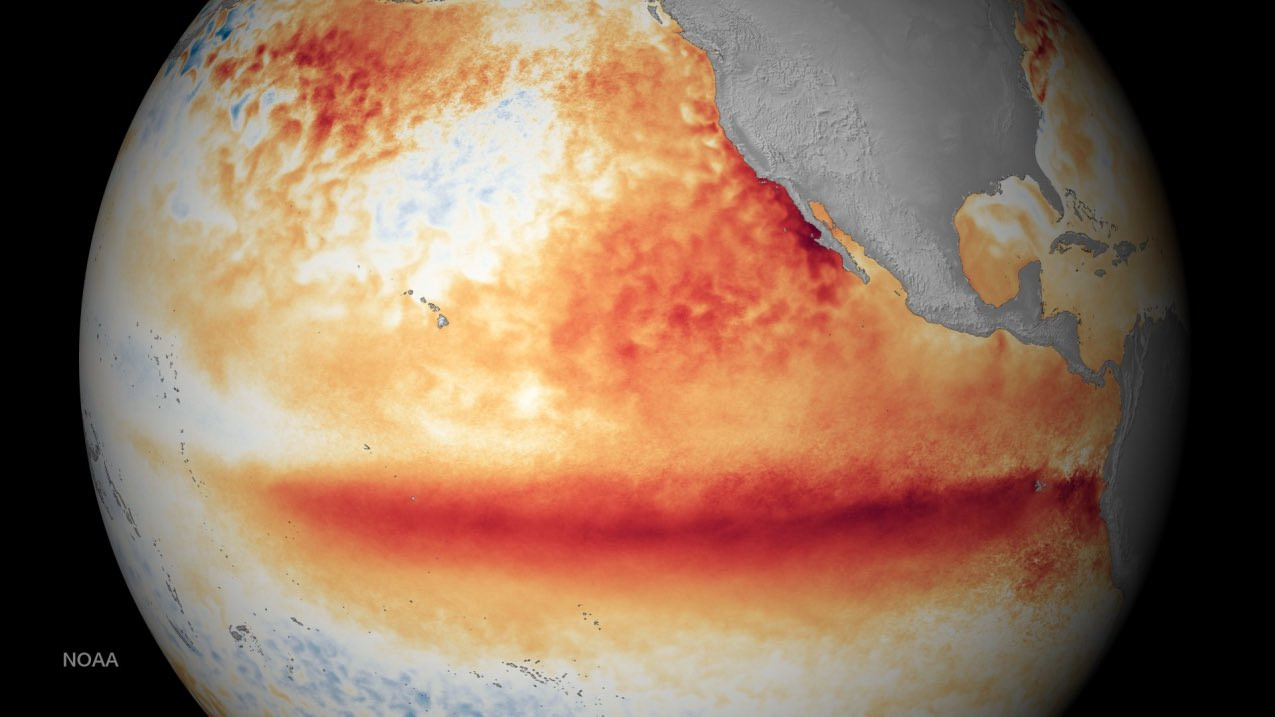
How a super-strong El Niño is different
While in an ordinary El Niño the water in the Pacific warms by tenths of a degree, in a super-strong one it warms by more than two degrees above the long-term average. That is enough to significantly alter atmospheric circulation and the distribution of rainfall across the entire planet.
The strongest events almost always lead to a record-warm year. Heat from the water is released and spreads across the tropical areas of the Pacific and subsequently over the whole planet.
An event of this magnitude occurs roughly once every 10 to 15 years.
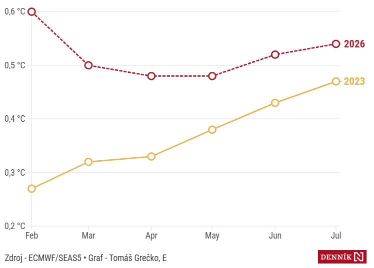
El Niño pushes temperatures up
How much higher global temperatures are than the long-term average – a comparison of 2023 (the last year with an El Niño occurrence) and the forecast for 2026 (°C).
What El Niño usually does to the weather:
- In tropical parts of the world the risk of drought and extreme heat increases – for example in India, Australia or parts of Africa.
- By contrast, areas such as Peru or Ecuador experience heavy rains and floods.
- The changes also affect the hurricane season – it tends to be weaker in the Atlantic and, on the contrary, more active in the Pacific.
Europe feels the effects indirectly: Above all through extreme heatwaves and drier summer periods, which repeatedly appeared during the last strong episodes.
For Central Europe this usually means higher temperatures, greater weather variability and a higher risk of drought.
Shock for the economy
In the past it was common for the price of rice on world markets to rise by as much as a third during an El Niño episode. The reason is usually a lack of rainfall in Asia. This also threatens harvests of cotton, maize and soybeans. Drought in Indonesia, Brazil, Colombia and the southern parts of Africa will probably push up global prices of coffee, cocoa and palm oil.
Although El Niño initially manifests itself as a warm current in the Pacific Ocean and is generally regarded as a “warm phase”, it should not be imagined only as extreme heat and drought.
For example, in Canada, changes in circulation have in the past brought milder winters, which benefited local fishers. In California, wetter weather has increased the yields of almonds and avocados.
However, calculations by scientists from 2023 showed that once indirect and long-term consequences are included, El Niño has a “persistent macroeconomic effect” associated with large and hitherto underestimated costs.
Moreover, accelerating global warming will erase some of the “positive” effects of El Niño and, conversely, extreme manifestations may become even stronger.
 Tomáš Grečko